HM

Hydrometeorological surveys in Moscow and Moscow Region

We study the climatic conditions of the site and the hydrological regime of water bodies. We determine climatic parameters for calculating snow and wind loads, glaze ice characteristics, and design water discharges and levels. This data is used when designing structures and flood protection measures.

  • we operate since 2013

Not a single negative expert review conclusion in 13 years

10 %143,605 %143,751 %143,90free-flowing (unimpounded)Q 1% = 6.6 m³/sMeleyevsky Brook, dam cross-sectionelevations — Baltic Height System, m
Dam in Busharino · Meleyevsky StreamHover over a level— we will show what the hydrologist calculates

What hydrometeorological surveys are

Hydrometeorological surveys — is the study of climate and water bodies in the construction area. A hydrologist collects long-term records from weather stations and gauges, surveys rivers and brooks, and calculates the parameters required for design: snow and wind loads, ice accretion, frost penetration, water discharges and water levels.

The climatic section is required for almost any capital construction project: it is used to design the roof, structural frame and heating system. The hydrological section is needed if there is a river, stream or pond nearby, when building bridges, dams, utility crossings beneath a channel, and in areas prone to flooding.

Interesting factHydrometeorology

A “100-year” flood can happen in successive years

This term describes a flood level with about a 1% chance of being reached or exceeded in any year. It does not promise a century-long gap. With constant annual probability and independent events, the chance of at least one such flood in 30 years is about 26%.

Source: USGS

Equal snow depths can hold different amounts of water

Fresh, fluffy snow and dense, settled snow of the same depth contain different amounts of water. Surveys therefore measure both depth and snow water equivalent: the water released when the snow melts.

Source: NOAA / National Weather Service

Development changes how rainfall behaves

Roofs, roads and parking areas reduce infiltration and send more water rapidly into drains and rivers. The same rainfall can place very different demands on drainage before and after development.

Source: USGS

A river can build its own temporary dam

Accumulating ice can block a river channel and raise water levels upstream. When the jam breaks, flooding can threaten downstream areas. Flood assessment therefore considers both river flow and ice conditions.

Source: NOAA / National Weather Service

What scope of surveys is required

Depends on whether there is a river, stream or water body nearby.

Buildings and sites with no rivers nearbyClimatic characteristicsStandard scope for most buildings, boiler houses, substations and utilities.
  • Air and soil temperatures, frost penetration
  • Precipitation, including daily maximum
  • Wind, snow and ice loads
  • Severe meteorological phenomena

from 110,000 ₽

Dams, bridges, crossings, waterside sitesClimate and hydrological calculationsWhen a structure stands near a river, stream or body of water, crosses them, or is at risk of flooding.
  • Channel and floodplain survey
  • Channel cross-section survey
  • Maximum and minimum water discharges
  • 1–10% exceedance probability water levels, ice regime, channel deformations

from 150,000 ₽

Scope and stages of hydrometeorological surveys

See a real example — surveys for of the dam on the Meleyevsky Stream at the confluence with the Setun: climate, morphological cross-sections, calculation of water discharges and levels allowing for river backwater.

12–5 days

Hydrometeorological background data coverage

2–5 days

We select the nearest weather stations and hydrological gauges with long observation records and verify whether their data are representative of the site. For the dam in Busharino, climate data were taken from the Novo-Iyerusalim, Naro-Fominsk and Mozhaysk stations, and runoff was derived from analogue gauged rivers.

Stage outcome: it is clear what data the calculations are based on.

Hydrometeorological coverage map
weather stations and hydrological gauges around the site
Hydrometeorological coverage map: project site, weather stations and stream gauges in the Moscow Region
7-25-HM-G1
21 day

Watercourse reconnaissance

1 day

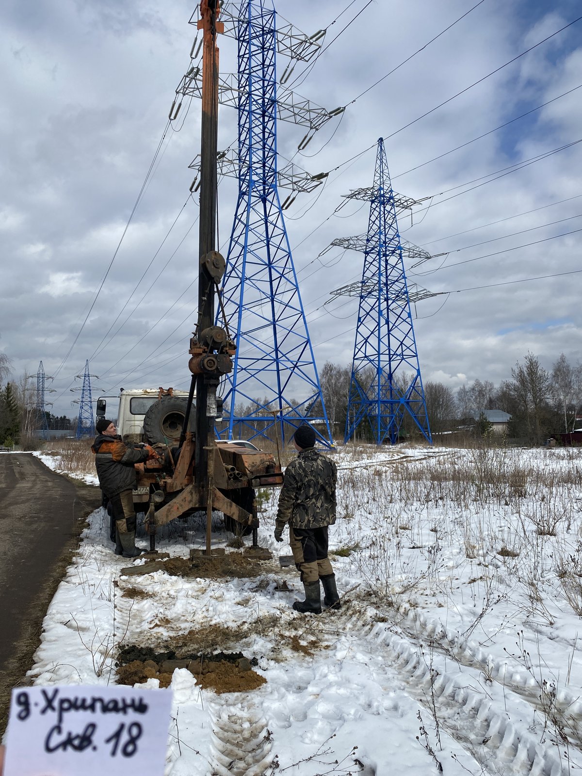
The hydrologist walks the channel and floodplain, looking for high-water marks on trees and banks, and assessing channel roughness, scour and debris jams. At Busharino, they found an old earth dam and signs of beaver activity — both of which affect water levels at the future dam site.

Stage outcome: description of the channel, floodplain and high-water marks.

Fieldwork in Busharino
from technical report 7-25-HM
Watercourse survey1 km
Catchment survey1 km
Hydromorphological survey1 km
Channel cross-section survey0.15 km
Calculation cross-sectionsbrook and river
7-25-HM
31 day

Channel cross-section survey

1 day

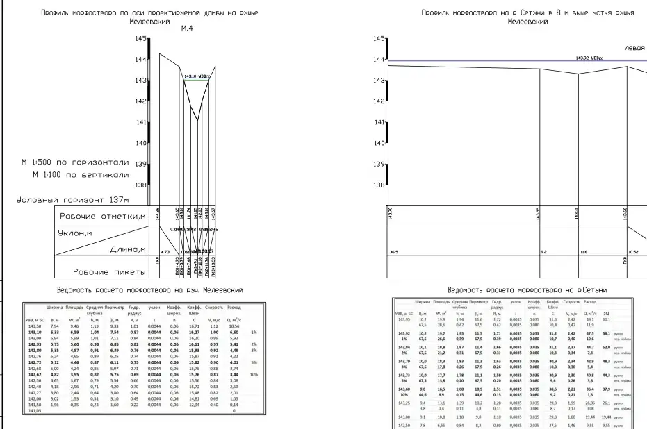
We survey cross-sections across the channel and floodplain using a total station and staff. From these, we plot the stage–discharge rating curve showing the water level for a given flow rate.

Stage outcome: channel and floodplain cross-sections at design stations.

Channel cross-sections on the stream and river
profiles and calculation schedule
Channel cross-sections on the Meleyevsky Stream and River Setun with discharge and water level calculation schedules
7-25-HM-G3
43–5 days

Climatic characteristics of the construction area

3–5 days

Using weather station records, we calculate everything the designer needs for load and building services calculations: temperatures, precipitation, wind, snow, glaze ice, frost penetration depth and hazardous phenomena.

For most projects without nearby rivers, this forms the main scope of hydrometeorological surveys.

Stage outcome: climatic parameters for structural and building services design.

Climate of the dam site
key design parameters
Climatic regionIIV
Coldest five-day period−28 °C
Snow regionIII — 1.5 kPa
Wind regionI — 0.23 kPa
Glaze ice districtII
Prevailing windssouthern
7-25-HM
55–7 days

Hydrological calculations: water discharges and levels

5–7 days

We calculate peak discharges for spring snowmelt and rain floods, minimum low-flow discharges and water levels for rare exceedance probabilities — 1, 2, 5 and 10%. We account for backwater from the main river, ice regime and channel deformations.

These figures determine the dam crest elevation, the soffit level of the bridge superstructure, the burial depth of the pipe beneath the riverbed, and flood protection for the site.

Stage outcome: design discharges and water levels for the project.

Brook water levels at the embankment dam section
allowing for backwater from the Setun, m BS
Exceedance probabilityLevel
1 %143,90
2 %143,82
3 %143,80
5 %143,75
10 %143,60

Ignoring backwater, the 1% AEP level would be 80 cm lower — 143.10 m.

7-25-HM
6total 3–5 weeks

Technical report on hydrometeorological surveys

total 3–5 weeks

Browse our report for the dam on the Meleyevsky Stream at its confluence with the River Setun. It includes:

  • Explanatory note — previous study coverage, physiographic conditions, climate, hydrological regime, discharge and water level calculations, hazardous phenomena, recommendations
  • Text appendices — technical brief, programme, spring flood characteristics based on an analogue river, morphological cross-section calculation sheets
  • Graphical appendices — study coverage diagram, morphological cross-sections with stage-discharge curves

Survey deliverables: technical report in electronic format for design and expert review.

91 sheets of this report. Client details, signatures and stamps have been redacted.

Technical Report 7-25-HM · dam on the Meleevsky Stream — original report in RussianSheet 1 of 91
Technical Report 7-25-HM · dam on the Meleevsky Stream, sheet 1
Sheet 1
Technical Report 7-25-HM · dam on the Meleevsky Stream, sheet 2
Sheet 2
Technical Report 7-25-HM · dam on the Meleevsky Stream, sheet 3
Sheet 3
Technical Report 7-25-HM · dam on the Meleevsky Stream, sheet 4
Sheet 4
Technical Report 7-25-HM · dam on the Meleevsky Stream, sheet 5
Sheet 5
Technical Report 7-25-HM · dam on the Meleevsky Stream, sheet 6
Sheet 6
Technical Report 7-25-HM · dam on the Meleevsky Stream, sheet 7
Sheet 7
Technical Report 7-25-HM · dam on the Meleevsky Stream, sheet 8
Sheet 8
Technical Report 7-25-HM · dam on the Meleevsky Stream, sheet 9
Sheet 9
Technical Report 7-25-HM · dam on the Meleevsky Stream, sheet 10
Sheet 10
Technical Report 7-25-HM · dam on the Meleevsky Stream, sheet 11
Sheet 11
Technical Report 7-25-HM · dam on the Meleevsky Stream, sheet 12
Sheet 12
Technical Report 7-25-HM · dam on the Meleevsky Stream, sheet 13
Sheet 13
Technical Report 7-25-HM · dam on the Meleevsky Stream, sheet 14
Sheet 14
Technical Report 7-25-HM · dam on the Meleevsky Stream, sheet 15
Sheet 15
Technical Report 7-25-HM · dam on the Meleevsky Stream, sheet 16
Sheet 16
Technical Report 7-25-HM · dam on the Meleevsky Stream, sheet 17
Sheet 17
Technical Report 7-25-HM · dam on the Meleevsky Stream, sheet 18
Sheet 18
Technical Report 7-25-HM · dam on the Meleevsky Stream, sheet 19
Sheet 19
Technical Report 7-25-HM · dam on the Meleevsky Stream, sheet 20
Sheet 20
Technical Report 7-25-HM · dam on the Meleevsky Stream, sheet 21
Sheet 21
Technical Report 7-25-HM · dam on the Meleevsky Stream, sheet 22
Sheet 22
Technical Report 7-25-HM · dam on the Meleevsky Stream, sheet 23
Sheet 23
Technical Report 7-25-HM · dam on the Meleevsky Stream, sheet 24
Sheet 24
Technical Report 7-25-HM · dam on the Meleevsky Stream, sheet 25
Sheet 25
Technical Report 7-25-HM · dam on the Meleevsky Stream, sheet 26
Sheet 26
Technical Report 7-25-HM · dam on the Meleevsky Stream, sheet 27
Sheet 27
Technical Report 7-25-HM · dam on the Meleevsky Stream, sheet 28
Sheet 28
Technical Report 7-25-HM · dam on the Meleevsky Stream, sheet 29
Sheet 29
Technical Report 7-25-HM · dam on the Meleevsky Stream, sheet 30
Sheet 30
Technical Report 7-25-HM · dam on the Meleevsky Stream, sheet 31
Sheet 31
Technical Report 7-25-HM · dam on the Meleevsky Stream, sheet 32
Sheet 32
Technical Report 7-25-HM · dam on the Meleevsky Stream, sheet 33
Sheet 33
Technical Report 7-25-HM · dam on the Meleevsky Stream, sheet 34
Sheet 34
Technical Report 7-25-HM · dam on the Meleevsky Stream, sheet 35
Sheet 35
Technical Report 7-25-HM · dam on the Meleevsky Stream, sheet 36
Sheet 36
Technical Report 7-25-HM · dam on the Meleevsky Stream, sheet 37
Sheet 37
Technical Report 7-25-HM · dam on the Meleevsky Stream, sheet 38
Sheet 38
Technical Report 7-25-HM · dam on the Meleevsky Stream, sheet 39
Sheet 39
Technical Report 7-25-HM · dam on the Meleevsky Stream, sheet 40
Sheet 40
Technical Report 7-25-HM · dam on the Meleevsky Stream, sheet 41
Sheet 41
Technical Report 7-25-HM · dam on the Meleevsky Stream, sheet 42
Sheet 42
Technical Report 7-25-HM · dam on the Meleevsky Stream, sheet 43
Sheet 43
Technical Report 7-25-HM · dam on the Meleevsky Stream, sheet 44
Sheet 44
Technical Report 7-25-HM · dam on the Meleevsky Stream, sheet 45
Sheet 45
Technical Report 7-25-HM · dam on the Meleevsky Stream, sheet 46
Sheet 46
Technical Report 7-25-HM · dam on the Meleevsky Stream, sheet 47
Sheet 47
Technical Report 7-25-HM · dam on the Meleevsky Stream, sheet 48
Sheet 48
Technical Report 7-25-HM · dam on the Meleevsky Stream, sheet 49
Sheet 49
Technical Report 7-25-HM · dam on the Meleevsky Stream, sheet 50
Sheet 50
Technical Report 7-25-HM · dam on the Meleevsky Stream, sheet 51
Sheet 51
Technical Report 7-25-HM · dam on the Meleevsky Stream, sheet 52
Sheet 52
Technical Report 7-25-HM · dam on the Meleevsky Stream, sheet 53
Sheet 53
Technical Report 7-25-HM · dam on the Meleevsky Stream, sheet 54
Sheet 54
Technical Report 7-25-HM · dam on the Meleevsky Stream, sheet 55
Sheet 55
Technical Report 7-25-HM · dam on the Meleevsky Stream, sheet 56
Sheet 56
Technical Report 7-25-HM · dam on the Meleevsky Stream, sheet 57
Sheet 57
Technical Report 7-25-HM · dam on the Meleevsky Stream, sheet 58
Sheet 58
Technical Report 7-25-HM · dam on the Meleevsky Stream, sheet 59
Sheet 59
Technical Report 7-25-HM · dam on the Meleevsky Stream, sheet 60
Sheet 60
Technical Report 7-25-HM · dam on the Meleevsky Stream, sheet 61
Sheet 61
Technical Report 7-25-HM · dam on the Meleevsky Stream, sheet 62
Sheet 62
Technical Report 7-25-HM · dam on the Meleevsky Stream, sheet 63
Sheet 63
Technical Report 7-25-HM · dam on the Meleevsky Stream, sheet 64
Sheet 64
Technical Report 7-25-HM · dam on the Meleevsky Stream, sheet 65
Sheet 65
Technical Report 7-25-HM · dam on the Meleevsky Stream, sheet 66
Sheet 66
Technical Report 7-25-HM · dam on the Meleevsky Stream, sheet 67
Sheet 67
Technical Report 7-25-HM · dam on the Meleevsky Stream, sheet 68
Sheet 68
Technical Report 7-25-HM · dam on the Meleevsky Stream, sheet 69
Sheet 69
Technical Report 7-25-HM · dam on the Meleevsky Stream, sheet 70
Sheet 70
Technical Report 7-25-HM · dam on the Meleevsky Stream, sheet 71
Sheet 71
Technical Report 7-25-HM · dam on the Meleevsky Stream, sheet 72
Sheet 72
Technical Report 7-25-HM · dam on the Meleevsky Stream, sheet 73
Sheet 73
Technical Report 7-25-HM · dam on the Meleevsky Stream, sheet 74
Sheet 74
Technical Report 7-25-HM · dam on the Meleevsky Stream, sheet 75
Sheet 75
Technical Report 7-25-HM · dam on the Meleevsky Stream, sheet 76
Sheet 76
Technical Report 7-25-HM · dam on the Meleevsky Stream, sheet 77
Sheet 77
Technical Report 7-25-HM · dam on the Meleevsky Stream, sheet 78
Sheet 78
Technical Report 7-25-HM · dam on the Meleevsky Stream, sheet 79
Sheet 79
Technical Report 7-25-HM · dam on the Meleevsky Stream, sheet 80
Sheet 80
Technical Report 7-25-HM · dam on the Meleevsky Stream, sheet 81
Sheet 81
Technical Report 7-25-HM · dam on the Meleevsky Stream, sheet 82
Sheet 82
Technical Report 7-25-HM · dam on the Meleevsky Stream, sheet 83
Sheet 83
Technical Report 7-25-HM · dam on the Meleevsky Stream, sheet 84
Sheet 84
Technical Report 7-25-HM · dam on the Meleevsky Stream, sheet 85
Sheet 85
Technical Report 7-25-HM · dam on the Meleevsky Stream, sheet 86
Sheet 86
Technical Report 7-25-HM · dam on the Meleevsky Stream, sheet 87
Sheet 87
Technical Report 7-25-HM · dam on the Meleevsky Stream, sheet 88
Sheet 88
Technical Report 7-25-HM · dam on the Meleevsky Stream, sheet 89
Sheet 89
Technical Report 7-25-HM · dam on the Meleevsky Stream, sheet 90
Sheet 90
Technical Report 7-25-HM · dam on the Meleevsky Stream, sheet 91
Sheet 91
7until the report is issued

Expert review support

until the report is issued

We respond to the expert reviewer's comments and refine calculations if necessary.

Positive conclusion
  • You submit the report for expert review and forward any comments to us
  • We contact the expert reviewer directly and resolve all queries
  • We support the report through to a positive expert review conclusion
  • Not a single negative expert review conclusion in 13 years

Our projects and prices for hydrometeorological surveys

Contract prices for hydrometeorological surveys on completed projects. Projects with photos feature a detailed breakdown of the work on a dedicated page.

These are just some of our projects — we carry out work on 40–50 sites every year.

How much do hydrometeorological surveys cost

We will provide an exact price on the day of your enquiry — based on the technical brief and site location plan.

Climatic characteristicsfrom 110,000 ₽
  • Duration3–5 weeks
  • With hydrological calculationsfrom 150,000 ₽

To get a quote, please send:

  • Location plan or cadastral number
  • What is being designed
  • Whether there is a river, stream or pond nearby
Get an estimate
  • What determines the price
  • Water bodieswhether there is a river or stream nearby and how many design cross-sections are required
  • Facility typea dam and a bridge require more calculations than a building
  • Existing knowledge of the areawhether there are nearby weather stations and gauges with long-term observation records
  • Backwater and icecomplex conditions mean more calculations
  • Lengthfor linear routes — number of watercourse crossings

Questions about hydrometeorological surveys

Which projects require hydrometeorological surveys?

For capital construction projects whose design is submitted for expert review — covering the climate summary: temperatures, precipitation, wind, snow and glaze ice. Hydrological calculations are added if water bodies are nearby or the site may be subject to flooding.

What is the 1% exceedance probability level?

This is the water level that is reached or exceeded on average once every 100 years. For critical structures, the designer sets elevations above this level with a safety margin.

What standards govern the surveys?

In accordance with SP 47.13330 "Engineering surveys for construction", SP 482.1325800 "Hydrometeorological surveys for construction" and SP 529.1325800 "Determination of main design hydrological characteristics"; climate and load zoning follow SP 131.13330 and SP 20.13330.

Can we just use data from the 'Construction Climatology' code of practice (SP)?

For some parameters, yes, but expert review requires a site area characterisation based on data from the nearest weather stations, including hazardous weather phenomena. We compile this in the report specifically referenced to your site.

How long does fieldwork take?

For a climate summary, a site visit is usually not required, or a single day of reconnaissance is sufficient. Watercourse inspection and cross-section surveying take 1–2 days per site.

How long are hydrometeorological survey results valid?

Under SP 47.13330.2016 (Cl. 7.1.8), the validity period of survey data is measured from the completion of surveys to the start of design: no more than 2 years for the hydrological regime of water bodies, and 5 years for the meteorological regime of the area. Older data may be used without additional surveys if a reconnaissance inspection reveals no changes in the water body regime, climate or man-made load. Data from state network gauges and stations do not expire; they are supplemented with records from the last 2 years for hydrology and 5 years for meteorology.

Send your technical brief — we will prepare a quotation the same day

If you do not have a technical brief, describe the project: site location, planned construction, and whether a design exists. We will reply with a scope of work and cost.