Industrial workshop, Podolsk
Geotechnical, topographic, environmental and hydrometeorological surveys for the construction of Production Shop No. 4 with an electron-beam processing unit on the site of an operating electrical installation products plant.


Objective
We completed geotechnical, topographic, environmental and hydrometeorological surveys for the design of Production Workshop No. 4 at an electrical installation products plant in Podolsk, featuring an electron-beam product modification unit based on a linear electron accelerator. The client is a construction company acting as the plant's general contractor; the works took place in September–November 2024 under a single contract covering four types of surveys.
A 72 × 36 m four-storey workshop standing 12.7 m high, without a basement; the foundation type was to be determined by the designers based on the survey findings. The 0.25 ha building footprint lies within an operating factory on a 5.4 ha site surrounded by existing buildings, district heating mains, cables and internal roads, so drilling and surveying were carried out in congested conditions and all utilities were signed off with six utility operators.
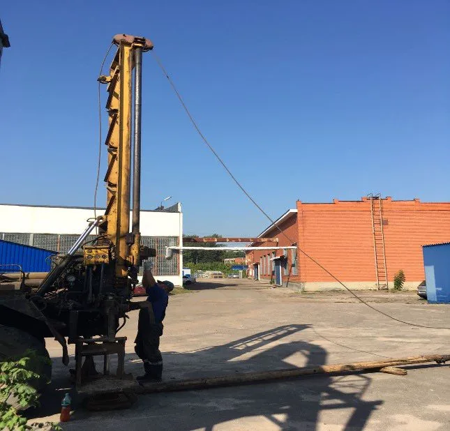
Four 15 m boreholes were drilled using a URB-2A-2 rig by core drilling with the recovery of 40 undisturbed samples; strength and deformation properties were determined in the laboratory by triaxial compression testing. The topographic survey was carried out from two newly established control points whose coordinates were determined by GNSS equipment referenced to MOBTI base stations; environmental engineers collected samples across the site and from boreholes and performed a radiation survey including radon flux density measurements.

Scope of work and deliverables
GTGeotechnical surveys
Scope of work
- 4 boreholes 15 m deep — 60 linear metres of 127 mm rotary core drilling
- sampling of 40 undisturbed cores, 10 disturbed samples and 3 soil samples for chemical analysis
- laboratory testing: physical properties on 12 samples, 24 triaxial compression tests, soil corrosivity to steel and concrete
- reconnaissance survey of the plant territory, horizontal and vertical referencing of exploratory holes
Results
- Geotechnical conditions — complexity category II (medium); the site lies on a gently undulating moraine plain with elevations of around 163–165 m.
- Beneath an engineered fill containing gravel, asphalt and construction debris (EGU-1a) lie stiff alluvial sandy clay (EGU-2), soft moraine sandy clay with sand interlayers (EGU-3) and firm moraine sandy clay with gravel (EGU-4), underlain at the base by plastic silty sand with interlayers of dense sand (EGU-5).
- There is no continuous groundwater horizon down to 15 m, but water-saturated sand interlayers were encountered in the soft loams; during precipitation and snowmelt, perched groundwater and standing water at the bottom of the excavation may occur.
- Soils are non-aggressive to concrete and reinforced concrete structures, and have moderate to high corrosivity to carbon steel.
- Standard frost penetration depth for loams is 1.10 m, with loams in the frost zone being moderately frost-susceptible; karst, suffosion and slope instability processes are not forecast.

- EGU-1a Made ground: engineered fill of cohesive soils with gravel, construction debris, asphalt and glass up to 30% (tQIV)
- EGU-2 Heavy sandy clay, stiff, with occasional interbeds of clay, alluvial (aQIII)
- EGU-3 Heavy sandy clay, firm, with frequent interbeds of silty sand and clayey sand, glacial till (gQIIms)
- EGU-4 Heavy sandy clay, very stiff, with interbeds of clay and gravel up to 10%, glacial till (gQIIms)
- EGU-5 Plastic silty sand with frequent interbeds of dense fine sand and light sandy clay, fluvioglacial and glaciolacustrine (f,lgQIId-ms)
- Groundwater level

Legend
- geotechnical borehole, number and depth, m
- geotechnical cross-section line, number
- footprint of the proposed workshop
TSTopographic surveys
Scope of work
- 1:500 engineering topographic plan for a 0.8 ha site, contour interval — 0.5 m
- installation of 2 survey control points and determination of their coordinates by satellite positioning from MOBTI base stations, coordinate system — MSK-50
- survey and inspection of underground and aboveground plant utilities
- utility approvals with 6 operating organisations: gas, water utility, power grids, district heating and telecoms
Results
- The site has a slight slope, with elevations of 163–165 m; heating mains, cables, foul sewers and plant fencing are plotted on the plan.
- The completeness and accuracy of the plotted utilities were confirmed by approvals from six utility operators.

ESEnvironmental surveys
Scope of work
- 6 topsoil and subsoil samples to a depth of 2 m: heavy metals, petroleum hydrocarbons, benzo(a)pyrene; 2 samples each for microbiological and parasitological indicators
- reconnaissance gamma survey of 0.8 ha, gamma dose rate measurement at 20 control points, 6 samples for radionuclides, radon flux density at 3 points
- interpretation of satellite imagery, reconnaissance survey, enquiries to regulatory authorities, schematic map of environmental conditions
Results
- Soils and ground down to 2 m fall into the 'permissible' contamination category and are 'clean' by microbiological and parasitological indicators; unrestricted use is permitted.
- The radiation environment is normal: no anomalies, uniform gamma background, and radon flux density within regulatory limits.
- Total petroleum hydrocarbons content of 69–306 mg/kg — within permissible limits.

HMHydrometeorological surveys
Scope of work
- site climatic summary based on the nearest weather station: design and standard temperatures, precipitation, wind, snow and ice loads
- certificate from FGBU Central UGMS on hazardous hydrometeorological phenomena
- assessment of the impact of the nearest watercourses — the source of the Zhestvenka River and the Pakhra River — on the site
Results
- A climatic characterisation with design and normative meteorological parameters was prepared for design purposes.
- Water bodies do not affect the site: the source of the Zhestvenka is 830 m away and the River Pakhra is 3.3 km away; no works take place within water protection zones.
Site photos



Result
The client received four technical reports for the workshop design. A positive non-state expert review conclusion was obtained.
This is just one of our projects: every year our specialists carry out surveys on 40–50 sites in Moscow, the Moscow Region, and across Russia.
Send your technical brief — we will price it the same day
If you do not have a technical brief, describe the project: site location, planned construction, and whether a design exists. We will reply with a scope of work and cost.